


Description
What our Coordinate Planes & Real-World Problems lesson plan includes
Lesson Objectives and Overview: Coordinate Planes & Real-World Problems teaches students about using coordinate planes in real-world scenarios. At the end of the lesson, students will be able to solve real-world and mathematical problems by graphing points in all four quadrants of the coordinate plane and using the distance between the points. This lesson is for students in 6th grade.
Classroom Procedure
Every lesson plan provides you with a classroom procedure page that outlines a step-by-step guide to follow. You do not have to follow the guide exactly. The guide helps you organize the lesson and details when to hand out worksheets. It also lists information in the blue box that you might find useful. You will find the lesson objectives, state standards, and number of class sessions the lesson should take to complete in this area. In addition, it describes the supplies you will need as well as what and how you need to prepare beforehand.
Options for Lesson
Included with this lesson is an “Options for Lesson” section that lists a number of suggestions for activities to add to the lesson or substitutions for the ones already in the lesson. One optional addition to the lesson activity is to have your students research a city in a different country or time period in relation to other subjects they may be studying. For an additional activity, you can have your students make a map of an amusement park for customers. Finally, you could have students develop word problems that require using absolute value to solve for the distance using topics that are of interest to them.
Teacher Notes
The teacher notes page includes a paragraph with additional guidelines and things to think about as you begin to plan your lesson. This page also includes lines that you can use to add your own notes as you’re preparing for this lesson.
COORDINATE PLANES & REAL-WORLD PROBLEMS LESSON PLAN CONTENT PAGES
Coordinate Planes & Real-World Problems
The Coordinate Planes & Real-World Problems lesson plan includes three pages of content. When graphing an ordered pair on a coordinate plane, you first need to find the x-coordinate on the x-axis. Next, you move up or down from that point to the value of the y-coordinate. This intersection of the value of the x-coordinate and y-coordinate is where you will place your point!
The lesson includes an example with the point (2, -4). To graph this, you would find 2 on the x-axis and then move down to negative 4, placing the point at that intersection.
Next, if you want to find the distance between two points, you can use one of two methods. You can either use a graph or you can look at the values of the coordinates. Using a graph, you can count the distance between the two points.
The lesson includes an example of a graph with the ordered pairs (-2, 3) and (-2, 5). These points lie on a vertical line. If you count the distance between the two points, you will find that the points are 8 units apart. The lesson also includes an example of a graph with the ordered pairs (-2, 1) and (1, 1). These points lie on a horizontal line. If you count the distance between the two points, you will find that the points are 3 units apart.
Using Ordered Pairs
You can also find the distance between a set of ordered pairs without a graph. To start, you’ll look at the x and y coordinates and determine if either of them match. If the x-coordinates are the same, the points lie on a vertical line. To find the distance between the points, you just need to find the absolute value of each y-coordinate and add them together.
If the y-coordinates are the same, the points lie on a horizontal line. To find the distance between the points, you just need to find the absolute value of each x-coordinate and add them together. If neither the x or y-coordinates are the same, that means the line is not vertical or horizontal and the points don’t lie on a line.
The lesson includes a few examples to illustrate these concepts. The first example uses the points (8, -1) and (8, 10). The x-coordinates of these points are the same, so we know that the points are on a vertical line. We can find the distance between them by adding together the absolute values of the y-coordinates: |–1| + |10| = 1 + 10 = 11 units. The total distance between the points is 11 units.
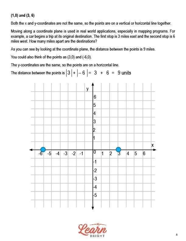
In another example using the points (1, 0) and (3, 6), the x and y-coordinates are not the same so they are not on a vertical or horizontal line together.
We can use coordinate planes in many real-world applications, like mapping programs. You might have a car that begins its trip in one destination and makes two stops, one 3 miles east and one 6 miles west. If you wanted to find out how many miles apart the destinations are, you can use a coordinate plane. When you look at these points on a coordinate plane, you can see that they are 9 units, or 9 miles, apart. You can also find the distance without a graph by adding together the absolute values of the x-coordinates (3 and 6).
COORDINATE PLANES & REAL-WORLD PROBLEMS LESSON PLAN WORKSHEETS
The Coordinate Planes & Real-World Problems lesson plan includes three worksheets: an activity worksheet, a practice worksheet, and a homework assignment. You can refer to the guide on the classroom procedure page to determine when to hand out each worksheet.
CITY MAP ACTIVITY WORKSHEET
For the activity worksheet, students will choose a real-world city and create a map for tourists using a coordinate plane. They will find five attractions in the city and use the coordinate plane to create a map of each of their locations, calculating the distance between each attraction.
COORDINATE PLANES & REAL-WORLD PROBLEMS PRACTICE WORKSHEET
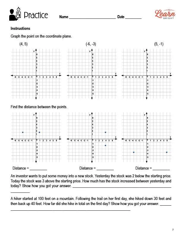
The practice worksheet asks students to complete three short exercises. For the first, they will graph points on coordinate planes. For the second, they will find the distance between two points on a coordinate plane. And for the third, they will solve two word problems involving coordinate planes.
VERTICAL OR HORIZONTAL HOMEWORK ASSIGNMENT
For the homework assignment, students will determine whether each given pair of endpoints lies on the same vertical or horizontal line. If they do, students will find the distance between the points. If they don’t, students will tell how they know the points don’t lie on a vertical or horizontal line.
Worksheet Answer Keys
This lesson plan includes answer keys for the practice worksheet and the homework assignment. If you choose to administer the lesson pages to your students via PDF, you will need to save a new file that omits these pages. Otherwise, you can simply print out the applicable pages and keep these as reference for yourself when grading assignments.